



Cloud dispatch, billing and inventory system built for petroleum carriers

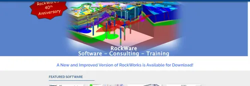
Geologists, environmental consultants and mining engineers collect measurements at points in the ground, usually boreholes, and then need to see what lies between them. RockWorks is subsurface visualization software from RockWare, a company in Golden, Colorado that says it was founded in 1983 to provide geoscience software and consulting. The company calls RockWorks the standard for surface and subsurface data visualization in the petroleum, environmental, geotechnical and mining industries.
The program turns drilling and survey data into visual outputs. It draws surface maps and borehole logs, and builds cross sections and fence diagrams that show how rock layers change from one borehole to the next. Because the same data can feed several of these products, a project team can move from a single log to a view of the whole site.
For three-dimensional work, RockWorks creates solid models and calculates volumes. That matters for tasks such as estimating how much material lies in a layer or an ore body, or how a contaminant plume is spread through the ground.
A strength the company points to is the range of data types the software takes in. These include stratigraphy and lithology, downhole geochemistry, geophysics and geotechnical measurements, color intervals, fractures and aquifer data. This breadth is why the same tool is used across the oil and gas, environmental, mining and civil engineering fields.
RockWare runs workshops in Golden, Colorado, and offers on-site classes and online training, as well as a library of training videos and a knowledge base for the product. Its consulting arm covers oil and gas, mining, environmental, hydrogeology and geotechnical work, and the services it lists include litigation support, geological services, modernization and data management, and geological animations.
RockWare sells a range of other tools alongside RockWorks. LogPlot plots borehole logs, PetraSim handles flow, transport and heat modeling including geothermal reservoir simulation, and AqQA analyses water chemistry. Other items in its catalog cover contouring, stereonets and rose diagrams, circular statistics, well log analysis, and converters between shapefiles and CAD formats.
Customers have access to a support portal, a user forum, documentation, downloads of updates and earlier versions, a free trial and licensing set-up help. The company's catalog also mentions academic discounts and custom estimates for ordering.
RockWorks is subsurface visualisation software from RockWare, a Golden, Colorado company that has supplied geoscience software and consulting since 1983. It is used to turn borehole and surface data into maps and models.
Petroleum, environmental, geotechnical and mining users. RockWare also runs two-day RockWorks training workshops in Golden and offers consulting.
Summary written by TrustList from the business's own published information, Nov 2026.
2 images - click to enlarge
Used it? Your experience helps other buyers decide.
Write a reviewNo questions yet. Be the first to ask about RockWorks.
Similar listings buyers compare against this one.
Cloud dispatch, billing and inventory system built for petroleum carriers

Economic evaluation software for oil and gas reserve reporting and prospect analysis

Geological and geophysical interpretation software for oil and gas geoscientists
ERP software for oilfield service, inspection, rental, repair and light manufacturing businesses
Web platform that pulls drilling, land, production and accounting data into shared dashboards
Back-office accounting and land software for oil and gas companies, from P2 Energy Solutions
Planning, operations and reserves software for exploration and production companies
Articles that share the Spatial Analysis tag or mention this listing.
 DataBase
20 Nov 2026
PostgreSQL 19 adds REPACK CONCURRENTLY and logical replication without a restart, removes RADIUS authentication, warns on MD5 passwords,…
 Cybersecurity
20 Nov 2026
Synology advisory SA-26:21 of 19 November 2026 rates CVE-2026-120382 in the DSM and BeeStation OS OAuth API critical (CVSS 9.8); DSM…
 Taiwan
10 Nov 2026
No workaround exists, and a second advisory published the same minute lists 25 more DSM flaws, with fixes named only for the two newest…
Everything here links back to the same verified catalogue. Pick your next stop.


